The USDA Rural Utilities Service (RUS) Telecommunications Program supports the publication of geospatial visualizations related to its loan and grant portfolio. These visualizations are intended to help stakeholders easily identify possible partnerships and to aid in the review of new loan and grant applications. The Telecommunications Program is eager to continue its GIS efforts as a public service to provide a clear representation of its ongoing investments in rural America and Agency objectives.
Public Searchable Map Database
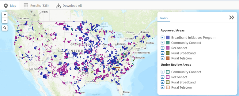
The Public Searchable Map Database provides public information about service areas in the United States, US Territories, and Compacts of Free Association (COFA) sovereign states for projects that have either received funding from, or are under review for funding, from the RUS Telecommunications Program. All applications that are not funded will be removed from the map.
The Public Searchable Map Database allows you to view existing applications (Under Review or Approved) and their related service areas for the following funding programs:
• Broadband Initiatives Program
• Community Connect
• ReConnect
• Rural Broadband
• Telecommunications Infrastructure Program
The Public Searchable Map Database replaces the Telecommunications Program Funded Service Areas Map and includes enhanced functionality such as advanced Search Filters and a downloadable Results Table.
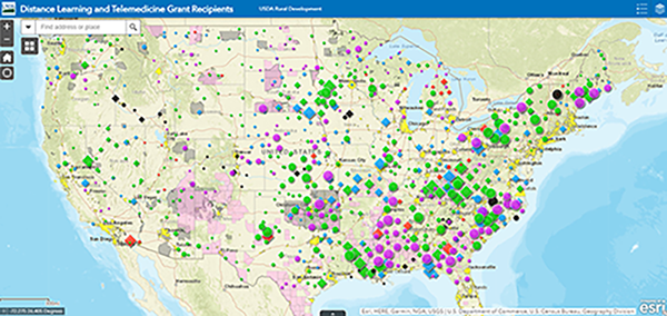
Distance Learning and Telemedicine (DLT) Grant Recipients
This map identifies all of the Distance Learning and Telemedicine sites that were approved and obligated as of the Fiscal Year 2017 DLT application window. If a project was fully rescinded any time after it was obligated, the fully rescinded project will not appear on the map.
DLT projects appear on the map as a part of either the Distance Learning or Telemedicine layer. Each layer is further broken down by grant sub-type (Opioid, Special Opioid, STEM, Substance Abuse Disorder, or Traditional) and each sub-type is identified by a different symbol on the map. These two layers appear on the map as clustered groups by grant sub-type, which means that as a user zooms out, more sites are aggregated into fewer groups, while zooming in creates more clustered groups containing fewer sites. If a user clicks on a clustered group, the pop-up box displays information about the cluster, including the number of sites in that cluster. At any point, a user may view site-specific information for each site within a cluster by selecting the Browse Features link located at the bottom of the pop-up box. Users can also select the Zoom to link located at the bottom of the pop-up box to zoom in to a specific area on the map containing that cluster. If a user zooms in to a level where the clustering area only contains a single site, a pop-up box displays information specific to that site once selected.